My ride yesterday was typified by triple digits – both in temperature and in mileage. On Friday morning, I should have been starting out on a 1000K ride from Seattle to Klamath Falls, but canceled that adventure in deference to the concerns of my family and doctors. As it turns out the challenges of the local 200K permanent I did instead were plentiful.
Leaving Pasadena at 8AM, the sun was already beating down, though the heat would exceed the forecast by 10 or 15º by mid-day. I kept cadence to the march of a group of Marines trotting along in the opposite direction in double-time. The climbing, mild as it was, started right away – dodging traffic through Altadena, passing by Descanso Gardens – then climbing over the Verdugo hills before descending into Glendale/La-Crescenta/Montrose and bombing down Foothill Blvd back into the San Fernando valley.
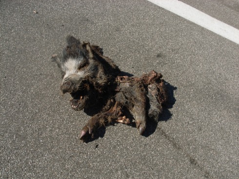
Then I started the first “real” climb of the day, up over Little Tujunga (discussed previously). I tried to hold something back knowing I’d have to come back over these twin summits later in the afternoon – but I was feeling strong, and my exuberance took hold when I noticed a couple cyclists weaving their way up the switch-backs overhead. Climbing out of the saddle, I pushed on eventually overtaking the two roadies as we exchanged brief pleasantries remarking on the (thus far) beautiful weather and low traffic. Rounding one of the final bends I encountered a greusome yet fascinating sight – it appears that Angeles National Forest is home to wild boar!
I should have stopped at Mushroom summit to eat, but I motored down-hill instead, making my way up to Bear Divide, and then down Sand Canyon past ranches where horses raced along-side me just beyond their wooden fences. I stopped at In-N-Out as a control, re-filling my water bottles and downing most of a chocolate shake (I ended up tossing the last third of the shake when a bee drowned himself in the cup). On my training rides I would turn East at this point, but this permanent had me continue West through Santa Clarita. Quail and squirrels (one weighted down by a hamburger sized payload) scurried across my path, but thankfully had the sense to stay out of my spokes.
Passing by the backside of Magic Mountain, I passed through a number of round-abouts as the roller-coasters grew in prominence. “Bayview,” “Island,” “Stanford,” “Rockefeller,” – all examples of the street names flanking Bridgeport Park seem to reflect the aspirations of affluence common to the residents of this pocket of Valencia. Not much further down the road though and the idealic artificial rivers are replaced by bleak office parks and parched hills. Catching the draft of the numerous semis going down Highway 126 I was in Piru before I knew it. I re-filled my water bottles again and downed a large lemonade, a large chocolate milk, and a large horchata before heading back up the long false flats.
The return trip just kept growing hotter and hotter; the tarmac was like a frying pan, roasting rattle-snake and jalapeño alike (I saw many of both). My energy was waning, and the rice balls I had brought to fortify myself had deteriorated to an inedible mush. The 12 mile stretch that only took 20 minutes the first time, took more than twice as long to re-trace. The mist from some sprinklers watering the orange groves and red pepper plants was all that kept me moving forward at times. Back in Valencia, I stopped three times in as many miles to buy more drinks, downing smoothies, carrot juice, coconut water, and re-filling both water bottles again at a park drinking fountain. I couldn’t seem to get enough liquid, electrolytes, or calories.
Slowly spinning my way up Placerita Canyon, I was supposed to answer a question on my brevet card (this serves as an “information control” proving you didn’t take any short-cuts on the route) at a particular cross street, but it never seemed to appear. Meanwhile, the road pitched upwards, growing much steeper than the maps I’d skimmed seemed to suggest. The canyon faces pushed in on the narrow road, and civilization fell away, replaced by scalding open spaces. I emptied one water bottle, and had to start rationing my second – both were the temperature of tea and did little to stave off the looming heat stroke.
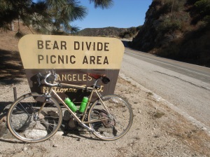
When I finally reached Sand Canyon, I realized I either had to go back to Santa Clarita to re-fill my water bottles (and then re-climb the hill) or just push forward to Bear Summit where there was water at a campground/picnic area. I chose the latter, thinking I’d rather get the suffering over with (and doubting my resolve to finish the ride if I let myself get off route). The sun and the grade were unrelenting, and even in my “granny-gear” I was beginning to get terrible cramps in my hamstrings, quads, and calves. Each time I reached a shady spot or my leg cramped to the point that I couldn’t pedal, I got off the bike took a tiny sip of water and walked on (several times beset by bees trying to take up residence in my helmet). So began a pattern of ride, cramp, walk…ride, cramp, walk…ride, cramp, walk…until finally I reached Bear Summit:
Unfortunately the water fountain there had been capped and the water shut off, so I ended up begging for a few ounces of hot bottled water from a kind couple who were hanging out at the picnic area. I downed that in an instant and then coasted to a stop down to the base of the final hard climb of the day, back up Mushroom Summit. The cramp, ride, walk pattern soon resumed – and it was with much profanity that I eventually crested the final rise.
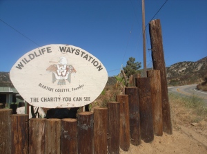
Coasting down the twisting descent (avoiding the wild boar once again), I pulled into the Wildlife Waystation, going around back and filling my bottle using a hose. Just as I was about to put the cap on, one of the women that works there popped out and said, “You can’t drink that water.” Turns out it wasn’t potable – she very nicely rinsed out my bottle and filled it with cool drinking water from inside the building, gently chastising me for getting water without asking and asking me to tell my cycling buddies not to do the same, else they get sick.
 I’ve never tasted anything so good in my life.
I thanked her profusely and made it back to the valley in one piece, stopping at another 7-11 to re-fuel (alleviating much of the cramping). The rest of the ride was slow-ish but otherwise without incident. I ended up at the final control exactly 10 hours from when I started, downing one last pint of chocolate milk before taking my brevet card and receipts to the permanent route owner’s house and then catching the light rail and subway back home. The subway was packed with cyclists on their way to battle it out in bike-polo bouts, and most of those I talked to thought I was a bit mental for riding all day in this heat. I tended to agree.
My hearing problems seemed strangely to improve during the ride, though they seemed a bit worse while I was recovering the rest of the evening. I may need to see an audiologist to solve this, but full recovery could take months, so I’m trying to be patient (difficult for a music lover).
At the end of the night, after a much needed shower and a dinner of steak and chard (from our garden), I went to the store and rewarded myself with a gallon of grapefruit juice, a sixer of brown ale, chips and salsa, and some chocolate cake…


In preface,
You are going to have to start inviting me to some of your awesome rides.
Once again you combination of awesome rides with great story telling keeps me on my toes looking for the lookout for your next blog. I personally love little T to bear divide but I always continue to camp 9 where there is water, a view, and if you’re lucky a helicopter.
I wondered if Camp 9 had water – but didn’t feel like climbing up there to find out. Thanks for the tip though!
If you want to try out the rando thing, you should sign up for the 200K coming up in November. It goes from Malibu to Carpinteria and back, only 1500 feet of climbing, so not exactly “epic” but it would give you a taste of this style of riding. Check out http://www.pchrandos.com
On October 9th we’ll be riding from Salinas (taking Amtrak up on the 8th) out to Big Sur then down the coast all the way to Ventura (then maybe cutting inland to Moorpark) – 375 miles. I’m tempted to try to ride it straight through (in <24hrs), but there is quite a bit of climbing (12,000 feet?) in the first 200 miles so I may change my tune when I'm out on the road.
In any case, I'd still like to go up 39 when it cools off a bit, though I'm not sure I can keep up with you 😉
I'll be in touch, and thanks for reading.
I’ve never heard of Mushroom Summit. Where exactly is that? You dont have a shot of it on map do you?
I can’t remember where I picked up that name, but it just refers to the “first summit” of Little Tujunga. There is a cement bunker just NE of Little T and Pacoima Rd (aka Forest Rte 4N35) that I believe has something to do with the name.